


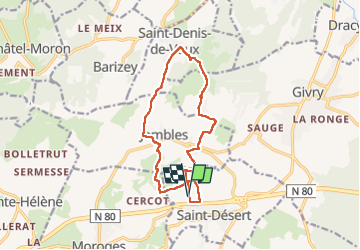
St-Désert Saint-Denis-de-Vaux en boucle

Papé TB
User

Length
12.9 km

Max alt
436 m

Uphill gradient
512 m
Km-Effort
19.8 km

Min alt
234 m

Downhill gradient
514 m
Boucle
Yes
Creation date :
2022-04-13 11:30:33.0
Updated on :
2022-04-15 07:20:28.117
3h22
Difficulty : Medium

FREE GPS app for hiking
 SityTrail
IGN / Geographical institutes
SityTrail Plus
The world is yours!
About
Trail Walking of 12.9 km to be discovered at Bourgogne-Franche-Comté, Saône-et-Loire, Saint-Désert. This trail is proposed by Papé TB.
Description
St-Désert, Montbogre, Mont-Avril, Jambles, Saint-Denis-de-Vaux, Russilly, Charnailles, Mont-Pouroux, Montbogre, St-Désert
Positioning
Country:
France
Region :
Bourgogne-Franche-Comté
Department/Province :
Saône-et-Loire
Municipality :
Saint-Désert
Location:
Unknown
Start:(Dec)
Start:(UTM)
629985 ; 5179744 (31T) N.
Comments