


Noturne

PhilippeC54
User
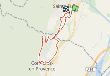

Length
8 km

Max alt
424 m

Uphill gradient
165 m
Km-Effort
10.2 km

Min alt
291 m

Downhill gradient
166 m
Boucle
Yes
Creation date :
2022-04-13 18:42:41.331
Updated on :
2022-04-13 19:51:47.004
45m
Difficulty : Easy

FREE GPS app for hiking
 SityTrail
IGN / Geographical institutes
SityTrail Plus
The world is yours!
About
Trail Mountain bike of 8 km to be discovered at Provence-Alpes-Côte d'Azur, Alpes-de-Haute-Provence, Sainte-Tulle. This trail is proposed by PhilippeC54.
Positioning
Country:
France
Region :
Provence-Alpes-Côte d'Azur
Department/Province :
Alpes-de-Haute-Provence
Municipality :
Sainte-Tulle
Location:
Unknown
Start:(Dec)
Start:(UTM)
722571 ; 4851383 (31T) N.
Comments