


A

janussity
User

Length
15 km

Max alt
615 m

Uphill gradient
395 m
Km-Effort
20 km

Min alt
325 m

Downhill gradient
395 m
Boucle
Yes
Creation date :
2022-04-14 07:34:57.481
Updated on :
2022-04-14 14:01:00.756
4h11
Difficulty : Very difficult

FREE GPS app for hiking
 SityTrail
IGN / Geographical institutes
SityTrail Plus
The world is yours!
About
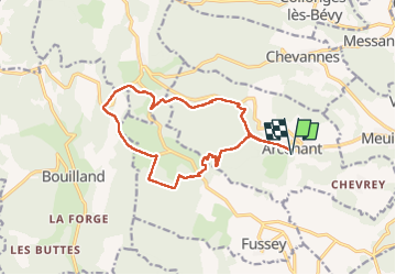
Trail Walking of 15 km to be discovered at Bourgogne-Franche-Comté, Côte-d'Or, Arcenant. This trail is proposed by janussity.
Description
Temps ensoleillé
Montée classée difficile pour accéder au site du Trou du Duc: falaises...
Photos


Positioning
Country:
France
Region :
Bourgogne-Franche-Comté
Department/Province :
Côte-d'Or
Municipality :
Arcenant
Location:
Unknown
Start:(Dec)
Start:(UTM)
639869 ; 5222114 (31T) N.
Comments