


ANNOT GD TOUR

pringel
User
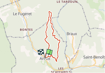

Length
13.6 km

Max alt
1369 m

Uphill gradient
732 m
Km-Effort
23 km

Min alt
692 m

Downhill gradient
733 m
Boucle
Yes
Creation date :
2022-04-14 15:51:05.521
Updated on :
2022-04-14 15:51:51.937
5h18
Difficulty : Medium

FREE GPS app for hiking
 SityTrail
IGN / Geographical institutes
SityTrail Plus
The world is yours!
About
Trail On foot of 13.6 km to be discovered at Provence-Alpes-Côte d'Azur, Alpes-de-Haute-Provence, Annot. This trail is proposed by pringel.
Positioning
Country:
France
Region :
Provence-Alpes-Côte d'Azur
Department/Province :
Alpes-de-Haute-Provence
Municipality :
Annot
Location:
Unknown
Start:(Dec)
Start:(UTM)
312904 ; 4870747 (32T) N.
Comments