


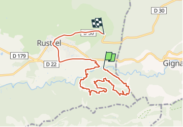
Le Colorado Provençal

micheldutilleul
User

Length
9.7 km

Max alt
511 m

Uphill gradient
275 m
Km-Effort
12.9 km

Min alt
353 m

Downhill gradient
131 m
Boucle
No
Creation date :
2022-04-14 12:07:15.528
Updated on :
2022-04-14 15:53:52.598
2h30
Difficulty : Easy

FREE GPS app for hiking
 SityTrail
IGN / Geographical institutes
SityTrail Plus
The world is yours!
About
Trail Walking of 9.7 km to be discovered at Provence-Alpes-Côte d'Azur, Vaucluse, Rustrel. This trail is proposed by micheldutilleul.
Description
Magnifique balade avec la découverte du Sahara, la source et les cheminées des fées.
Positioning
Country:
France
Region :
Provence-Alpes-Côte d'Azur
Department/Province :
Vaucluse
Municipality :
Rustrel
Location:
Unknown
Start:(Dec)
Start:(UTM)
700938 ; 4865819 (31T) N.
Comments