Trail Walking Arcenant - Arcenant-Trou du Duc-Site Gallo-Romain-Maquis - Photo

Arcenant-Trou du Duc-Site Gallo-Romain-Maquis

© OpenStreetMap contributors
Length
Length
11.6 km
Max alt
Max alt
577 m
Uphill gradient
Uphill gradient
376 m
Km-Effort
Km-Effort  
16.6 km
Min alt
Min alt
325 m
Downhill gradient
Downhill gradient
375 m
Boucle
Boucle
Yes
Creation date :
2022-04-15 07:56:34.307
Updated on :
2022-04-15 08:10:54.715

(0 Reviews)

Walking
Walking
3h46
Difficulty : Difficult

Scan this QR Code to open this trail in the SityTrail application

FREE GPS app for hiking

Logo SityTrail SityTrail

IGN / Geographical institutes

Download SityTrail from the App Store Download SityTrail from Google Play

Logo SityTrail SityTrail Plus

The world is yours!

Download SityTrail from the App Store Download SityTrail from Google Play Download SityTrail on Huawei AppGallery

About

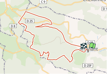
Trail Walking of 11.6 km to be discovered at Bourgogne-Franche-Comté, Côte-d'Or, Arcenant. This trail is proposed by janussity.

Description

Départ parking salle des fêtes d'Arcenant.
Montée régulière par la combe de Pertuis. Vue du Trou du Duc. Forêt d'Arcenant. Parcours boisé pour rejoindre l'Ecartelot (site gallo-romain). Maquis (monument) et retour Arcenant par combe Pourry.

Elevation profile

Positioning

Country:
France
Region :
Bourgogne-Franche-Comté
Department/Province :
Côte-d'Or
Municipality :
Arcenant
Location:
Unknown
Start:(UTM)
639865 ; 5222112 (31T) N.


Close
My subscriptions