


strava_min

Kaiser113
User
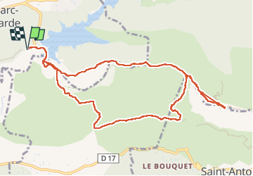

Length
12.9 km

Max alt
900 m

Uphill gradient
744 m
Km-Effort
23 km

Min alt
271 m

Downhill gradient
745 m
Boucle
Yes
Creation date :
2022-04-15 15:07:39.851
Updated on :
2022-04-15 15:09:14.323
5h11
Difficulty : Very difficult

FREE GPS app for hiking
 SityTrail
IGN / Geographical institutes
SityTrail Plus
The world is yours!
About
Trail Walking of 12.9 km to be discovered at Provence-Alpes-Côte d'Azur, Bouches-du-Rhône, Saint-Marc-Jaumegarde. This trail is proposed by Kaiser113.
Positioning
Country:
France
Region :
Provence-Alpes-Côte d'Azur
Department/Province :
Bouches-du-Rhône
Municipality :
Saint-Marc-Jaumegarde
Location:
Unknown
Start:(Dec)
Start:(UTM)
704549 ; 4824039 (31T) N.
Comments