


roche colombe la voie royale

raab
User
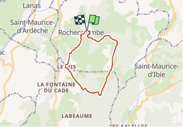

Length
11.7 km

Max alt
390 m

Uphill gradient
291 m
Km-Effort
15.6 km

Min alt
194 m

Downhill gradient
293 m
Boucle
Yes
Creation date :
2022-04-14 07:44:54.383
Updated on :
2022-04-16 07:18:05.861
4h59
Difficulty : Difficult

FREE GPS app for hiking
 SityTrail
IGN / Geographical institutes
SityTrail Plus
The world is yours!
About
Trail Walking of 11.7 km to be discovered at Auvergne-Rhône-Alpes, Ardèche, Rochecolombe. This trail is proposed by raab.
Positioning
Country:
France
Region :
Auvergne-Rhône-Alpes
Department/Province :
Ardèche
Municipality :
Rochecolombe
Location:
Unknown
Start:(Dec)
Start:(UTM)
614204 ; 4930543 (31T) N.
Comments