


Sait secret

raygautier
User
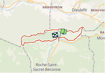

Length
16.9 km

Max alt
894 m

Uphill gradient
771 m
Km-Effort
27 km

Min alt
378 m

Downhill gradient
767 m
Boucle
No
Creation date :
2022-04-16 07:06:03.0
Updated on :
2022-04-16 17:29:29.286
8h41
Difficulty : Very difficult

FREE GPS app for hiking
 SityTrail
IGN / Geographical institutes
SityTrail Plus
The world is yours!
About
Trail Walking of 16.9 km to be discovered at Auvergne-Rhône-Alpes, Drôme, Roche-Saint-Secret-Béconne. This trail is proposed by raygautier.
Positioning
Country:
France
Region :
Auvergne-Rhône-Alpes
Department/Province :
Drôme
Municipality :
Roche-Saint-Secret-Béconne
Location:
Unknown
Start:(Dec)
Start:(UTM)
662413 ; 4929444 (31T) N.
Comments