


lavacherie bastogne

gue
User

Length
23 km

Max alt
566 m

Uphill gradient
442 m
Km-Effort
29 km

Min alt
364 m

Downhill gradient
315 m
Boucle
No
Creation date :
2014-12-10 00:00:00.0
Updated on :
2014-12-10 00:00:00.0
4h00
Difficulty : Unknown

FREE GPS app for hiking
 SityTrail
IGN / Geographical institutes
SityTrail Plus
The world is yours!
About
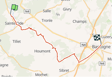
Trail Walking of 23 km to be discovered at Wallonia, Luxembourg, Sainte-Ode. This trail is proposed by gue.
Positioning
Country:
Belgium
Region :
Wallonia
Department/Province :
Luxembourg
Municipality :
Sainte-Ode
Location:
Lavacherie
Start:(Dec)
Start:(UTM)
680122 ; 5547120 (31U) N.
Comments