


ST GOUSSAUD - BOIS DE ROCHES

csy95
User
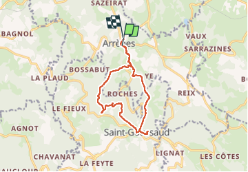

Length
12.4 km

Max alt
685 m

Uphill gradient
407 m
Km-Effort
17.8 km

Min alt
394 m

Downhill gradient
403 m
Boucle
No
Creation date :
2022-04-17 13:10:44.091
Updated on :
2022-04-18 08:49:31.319
2h59
Difficulty : Easy

FREE GPS app for hiking
 SityTrail
IGN / Geographical institutes
SityTrail Plus
The world is yours!
About
Trail Walking of 12.4 km to be discovered at New Aquitaine, Creuse, Arrènes. This trail is proposed by csy95.
Positioning
Country:
France
Region :
New Aquitaine
Department/Province :
Creuse
Municipality :
Arrènes
Location:
Unknown
Start:(Dec)
Start:(UTM)
389481 ; 5102873 (31T) N.
Comments