


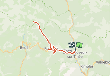
Vignols en partant de St Sauveur sur Tinée

franquen
User

Length
36 km

Max alt
1641 m

Uphill gradient
1498 m
Km-Effort
56 km

Min alt
505 m

Downhill gradient
1521 m
Boucle
No
Creation date :
2022-04-18 08:41:23.203
Updated on :
2022-04-18 17:10:13.2
4h00
Difficulty : Easy

FREE GPS app for hiking
 SityTrail
IGN / Geographical institutes
SityTrail Plus
The world is yours!
About
Trail Electric bike of 36 km to be discovered at Provence-Alpes-Côte d'Azur, Maritime Alps, Saint-Sauveur-sur-Tinée. This trail is proposed by franquen.
Description
Belle balade en pente régulière avec une pause resto à Roubion au retour (auberge du Moulin)
Positioning
Country:
France
Region :
Provence-Alpes-Côte d'Azur
Department/Province :
Maritime Alps
Municipality :
Saint-Sauveur-sur-Tinée
Location:
Unknown
Start:(Dec)
Start:(UTM)
348250 ; 4883370 (32T) N.
Comments