


randonnée marchin

René Strouwen
User
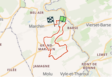

Length
12.1 km

Max alt
268 m

Uphill gradient
353 m
Km-Effort
16.8 km

Min alt
134 m

Downhill gradient
331 m
Boucle
No
Creation date :
2022-04-18 09:50:44.916
Updated on :
2022-04-18 13:21:10.959
3h11
Difficulty : Difficult

FREE GPS app for hiking
 SityTrail
IGN / Geographical institutes
SityTrail Plus
The world is yours!
About
Trail Walking of 12.1 km to be discovered at Wallonia, Liège, Marchin. This trail is proposed by René Strouwen.
Description
beau mais dure
Positioning
Country:
Belgium
Region :
Wallonia
Department/Province :
Liège
Municipality :
Marchin
Location:
Unknown
Start:(Dec)
Start:(UTM)
659689 ; 5594437 (31U) N.
Comments