


Tour de Chambly départ Ronquerolles

avdem
User
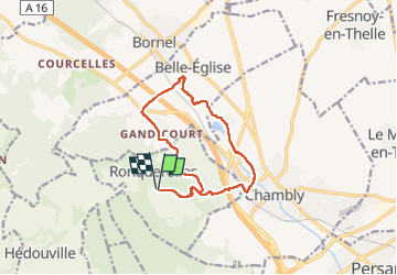

Length
12 km

Max alt
156 m

Uphill gradient
199 m
Km-Effort
14.6 km

Min alt
35 m

Downhill gradient
197 m
Boucle
Yes
Creation date :
2022-04-19 07:21:04.455
Updated on :
2022-04-19 10:19:12.005
2h50
Difficulty : Easy

FREE GPS app for hiking
 SityTrail
IGN / Geographical institutes
SityTrail Plus
The world is yours!
About
Trail Walking of 12 km to be discovered at Ile-de-France, Val-d'Oise, Ronquerolles. This trail is proposed by avdem.
Description
Dur à la fin
Photos


Positioning
Country:
France
Region :
Ile-de-France
Department/Province :
Val-d'Oise
Municipality :
Ronquerolles
Location:
Unknown
Start:(Dec)
Start:(UTM)
442284 ; 5446361 (31U) N.
Comments