


Saou

raygautier
User
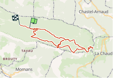

Length
21 km

Max alt
1572 m

Uphill gradient
1262 m
Km-Effort
38 km

Min alt
448 m

Downhill gradient
1290 m
Boucle
No
Creation date :
2022-04-18 06:32:13.0
Updated on :
2022-04-19 19:54:55.748
5h39
Difficulty : Very difficult

FREE GPS app for hiking
 SityTrail
IGN / Geographical institutes
SityTrail Plus
The world is yours!
About
Trail Walking of 21 km to be discovered at Auvergne-Rhône-Alpes, Drôme, Saou. This trail is proposed by raygautier.
Positioning
Country:
France
Region :
Auvergne-Rhône-Alpes
Department/Province :
Drôme
Municipality :
Saou
Location:
Unknown
Start:(Dec)
Start:(UTM)
668967 ; 4946516 (31T) N.
Comments