Montaigle boucle Ferme-Ruines-Hayettes-chateau

thomarche
User
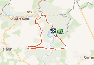

Length
7 km

Max alt
219 m

Uphill gradient
181 m
Km-Effort
9.4 km

Min alt
126 m

Downhill gradient
175 m
Boucle
Yes
Creation date :
2022-04-21 09:19:00.0
Updated on :
2022-04-21 11:24:24.417
1h53
Difficulty : Very easy

FREE GPS app for hiking
 SityTrail
IGN / Geographical institutes
SityTrail Plus
The world is yours!
About
Trail Walking of 7 km to be discovered at Wallonia, Namur, Onhaye. This trail is proposed by thomarche.
Description
Très beaux chemins. Macadam (très étroit, joli, et peu passant) sur la fin.
Positioning
Country:
Belgium
Region :
Wallonia
Department/Province :
Namur
Municipality :
Onhaye
Location:
Unknown
Start:(Dec)
Start:(UTM)
630117 ; 5571728 (31U) N.
Comments