


St die

ZAMBAUX
User
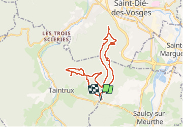

Length
17.7 km

Max alt
739 m

Uphill gradient
701 m
Km-Effort
27 km

Min alt
457 m

Downhill gradient
701 m
Boucle
Yes
Creation date :
2022-04-21 07:07:23.371
Updated on :
2022-04-21 13:26:47.878
6h18
Difficulty : Very difficult

FREE GPS app for hiking
 SityTrail
IGN / Geographical institutes
SityTrail Plus
The world is yours!
About
Trail Walking of 17.7 km to be discovered at Grand Est, Vosges, Saulcy-sur-Meurthe. This trail is proposed by ZAMBAUX.
Positioning
Country:
France
Region :
Grand Est
Department/Province :
Vosges
Municipality :
Saulcy-sur-Meurthe
Location:
Unknown
Start:(Dec)
Start:(UTM)
346115 ; 5345654 (32U) N.
Comments