![](/images/other/stat-length.png)
![Trail Walking Rueil-Malmaison - St Germain en Laye - Rueil Malmaison 28 km Inversee - Photo](https://media.geolcdn.com/t/1900/400/ext.pjpeg?maxdim=2&url=https%3A%2F%2Fmedia.geolcdn.com%2Ff%2Fb687f904-9338-4fa0-aef2-9bacff37d877.jpg)
St Germain en Laye - Rueil Malmaison 28 km Inversee
chessyca
User
![Length](/images/other/stat-length.png)
Length
28 km
![Max alt](https://static1.geolcdn.com/siteimages/upload/files/1508320355ic_sort_altitude_max_24dp.png)
Max alt
89 m
![Uphill gradient](https://static1.geolcdn.com/siteimages/upload/files/1508320355ic_sort_den_pos_24dp.png)
Uphill gradient
290 m
![Km-Effort](/images/other/stat-length.png)
Km-Effort
32 km
![Min alt](https://static1.geolcdn.com/siteimages/upload/files/1508320355ic_sort_altitude_min_24dp.png)
Min alt
17 m
![Downhill gradient](https://static1.geolcdn.com/siteimages/upload/files/1508320355ic_sort_den_neg_24dp.png)
Downhill gradient
235 m
![Boucle](https://static1.geolcdn.com/siteimages/upload/files/16400158638029165_repeat_loop_refresh_sync_direction_icon.png)
Boucle
No
Creation date :
2022-04-21 07:59:33.853
Updated on :
2022-05-21 20:11:02.07
![Walking](https://static1.geolcdn.com/sitytour/trail-icons/101.png)
6h00
Difficulty : Easy
![Scan this QR Code to open this trail in the SityTrail application](https://capi.geolives.com/qq0zvz2zws4bq2lad0pu/sitytour/trails/3213252/qr.png?size=200)
FREE GPS app for hiking
About
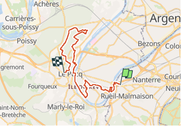
Trail Walking of 28 km to be discovered at Ile-de-France, Hauts-de-Seine, Rueil-Malmaison. This trail is proposed by chessyca.
Description
Une rando absolument féérique en cette saison
Un pur régal pour les yeux sans aucune difficulté
Menée et tracée par Brigitte
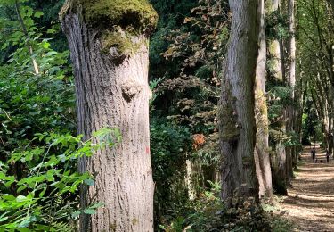
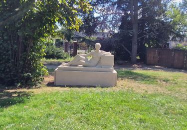
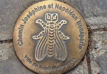
Positioning
Country:
France
Region :
Ile-de-France
Department/Province :
Hauts-de-Seine
Municipality :
Rueil-Malmaison
Location:
Unknown
Start:(Dec)
Start:(UTM)
439210 ; 5415299 (31U) N.
Comments
Trails nearby
![Trail Walking Bougival - Bougival-Saint-cucufa reel - Photo](https://media.geolcdn.com/t/375/260/ext.jpg?maxdim=2&url=https%3A%2F%2Fmedia.geolcdn.com%2Ff%2Ff8214235-f5e3-4ba5-8084-044ba7cbf132.jpeg)
![Walking Walking](https://static1.geolcdn.com/sitytour/trail-icons/101.png)
Bougival-Saint-cucufa reel
Walking
(1)
Bougival,
Ile-de-France,
Yvelines,
France
![](/images/other/stat-length.png)
7.7 km | 10.3 km-effort
2h 29min
![](https://static1.geolcdn.com/siteimages/upload/files/16400158638029165_repeat_loop_refresh_sync_direction_icon.png)
Yes
![Trail Walking Saint-Germain-en-Laye - SityTrail - 202230519 RS 5km - Photo](https://media.geolcdn.com/t/375/260/ext.jpg?maxdim=2&url=https%3A%2F%2Fstatic1.geolcdn.com%2Fsiteimages%2Fupload%2Ffiles%2F1553511878bg_sport_marche.png)
![Walking Walking](https://static1.geolcdn.com/sitytour/trail-icons/101.png)
SityTrail - 202230519 RS 5km
Walking
Easy
(1)
Saint-Germain-en-Laye,
Ile-de-France,
Yvelines,
France
![](/images/other/stat-length.png)
5 km | 5.6 km-effort
1h 16min
![](https://static1.geolcdn.com/siteimages/upload/files/16400158638029165_repeat_loop_refresh_sync_direction_icon.png)
Yes
![Trail On foot Rueil-Malmaison - SityTrail - 3850997 - rando-chatou (1) - Photo](https://media.geolcdn.com/t/375/260/ext.jpg?maxdim=2&url=https%3A%2F%2Fmedia.geolcdn.com%2Ff%2Fc514a42a-e126-47ef-85f0-d75f60d63c7a.jpg)
![On foot On foot](https://static1.geolcdn.com/sitytour/trail-icons/100.png)
SityTrail - 3850997 - rando-chatou (1)
On foot
Medium
Rueil-Malmaison,
Ile-de-France,
Hauts-de-Seine,
France
![](/images/other/stat-length.png)
32 km | 37 km-effort
8h 22min
![](https://static1.geolcdn.com/siteimages/upload/files/16400158638029165_repeat_loop_refresh_sync_direction_icon.png)
No
![Trail Walking Le Pecq - 20230707 RS - Photo](https://media.geolcdn.com/t/375/260/ext.jpg?maxdim=2&url=https%3A%2F%2Fstatic1.geolcdn.com%2Fsiteimages%2Fupload%2Ffiles%2F1553511878bg_sport_marche.png)
![Walking Walking](https://static1.geolcdn.com/sitytour/trail-icons/101.png)
20230707 RS
Walking
Easy
(1)
Le Pecq,
Ile-de-France,
Yvelines,
France
![](/images/other/stat-length.png)
5 km | 5.8 km-effort
1h 19min
![](https://static1.geolcdn.com/siteimages/upload/files/16400158638029165_repeat_loop_refresh_sync_direction_icon.png)
Yes
![Trail Road bike Paris - Bois de Boulogne Versaille - Photo](https://media.geolcdn.com/t/375/260/ext.jpg?maxdim=2&url=https%3A%2F%2Fstatic1.geolcdn.com%2Fsiteimages%2Fupload%2Ffiles%2F1524743154velo.jpg)
![Road bike Road bike](https://static1.geolcdn.com/sitytour/trail-icons/201.png)
Bois de Boulogne Versaille
Road bike
Easy
(1)
Paris,
Ile-de-France,
Paris,
France
![](/images/other/stat-length.png)
15.2 km | 18.2 km-effort
1h 29min
![](https://static1.geolcdn.com/siteimages/upload/files/16400158638029165_repeat_loop_refresh_sync_direction_icon.png)
No
![Trail Walking La Celle-Saint-Cloud - 2022-10-14_12h45m19_de bougival à rueil malmaison - Photo](https://media.geolcdn.com/t/375/260/ext.jpg?maxdim=2&url=https%3A%2F%2Fstatic1.geolcdn.com%2Fsiteimages%2Fupload%2Ffiles%2F1553511878bg_sport_marche.png)
![Walking Walking](https://static1.geolcdn.com/sitytour/trail-icons/101.png)
2022-10-14_12h45m19_de bougival à rueil malmaison
Walking
Difficult
(1)
La Celle-Saint-Cloud,
Ile-de-France,
Yvelines,
France
![](/images/other/stat-length.png)
14.4 km | 17.5 km-effort
3h 58min
![](https://static1.geolcdn.com/siteimages/upload/files/16400158638029165_repeat_loop_refresh_sync_direction_icon.png)
No
![Trail Walking Rueil-Malmaison - De Rueil Malmaison aux Serres d'Auteuil via Suresnes - Photo](https://media.geolcdn.com/t/375/260/ext.jpg?maxdim=2&url=https%3A%2F%2Fmedia.geolcdn.com%2Ff%2F69c5aa69-7a4f-4e7d-be07-682d5ba1172b.jpg)
![Walking Walking](https://static1.geolcdn.com/sitytour/trail-icons/101.png)
De Rueil Malmaison aux Serres d'Auteuil via Suresnes
Walking
Very easy
Rueil-Malmaison,
Ile-de-France,
Hauts-de-Seine,
France
![](/images/other/stat-length.png)
22 km | 26 km-effort
5h 3min
![](https://static1.geolcdn.com/siteimages/upload/files/16400158638029165_repeat_loop_refresh_sync_direction_icon.png)
No
![Trail Walking Rueil-Malmaison - Domaine Malmaison - Cité jardin Suresnes - Boulogne - Serres d'Auteuil - Photo](https://media.geolcdn.com/t/375/260/ext.jpg?maxdim=2&url=https%3A%2F%2Fmedia.geolcdn.com%2Ff%2Ff35951a9-b213-4c85-9bfa-cc06ec3dd722.jpg)
![Walking Walking](https://static1.geolcdn.com/sitytour/trail-icons/101.png)
Domaine Malmaison - Cité jardin Suresnes - Boulogne - Serres d'Auteuil
Walking
Easy
Rueil-Malmaison,
Ile-de-France,
Hauts-de-Seine,
France
![](/images/other/stat-length.png)
22 km | 27 km-effort
4h 54min
![](https://static1.geolcdn.com/siteimages/upload/files/16400158638029165_repeat_loop_refresh_sync_direction_icon.png)
No
![Trail Walking Rueil-Malmaison - De rueil Malmaison à St Germain en Laye - Photo](https://media.geolcdn.com/t/375/260/ext.jpg?maxdim=2&url=https%3A%2F%2Fmedia.geolcdn.com%2Ff%2F2cfb8298-4a88-4640-a039-54786d423968.jpg)
![Walking Walking](https://static1.geolcdn.com/sitytour/trail-icons/101.png)
De rueil Malmaison à St Germain en Laye
Walking
Medium
Rueil-Malmaison,
Ile-de-France,
Hauts-de-Seine,
France
![](/images/other/stat-length.png)
28 km | 32 km-effort
5h 56min
![](https://static1.geolcdn.com/siteimages/upload/files/16400158638029165_repeat_loop_refresh_sync_direction_icon.png)
No