Roppeviller (Rocher de Diane et Altschlossfelsen) 7 300m +187m

DanielROLLET
User
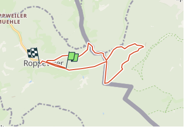

Length
7.3 km

Max alt
406 m

Uphill gradient
187 m
Km-Effort
9.9 km

Min alt
289 m

Downhill gradient
208 m
Boucle
No
Creation date :
2022-04-23 08:14:12.269
Updated on :
2022-08-24 07:41:33.177
2h12
Difficulty : Medium

FREE GPS app for hiking
 SityTrail
IGN / Geographical institutes
SityTrail Plus
The world is yours!
About
Trail Walking of 7.3 km to be discovered at Grand Est, Moselle, Roppeviller. This trail is proposed by DanielROLLET.
Description
Départ parking
Retour église
Positioning
Country:
France
Region :
Grand Est
Department/Province :
Moselle
Municipality :
Roppeviller
Location:
Unknown
Start:(Dec)
Start:(UTM)
391673 ; 5439671 (32U) N.
Comments