


Bajus
© OpenStreetMap contributors


2h35
Difficulty : Difficult


Length
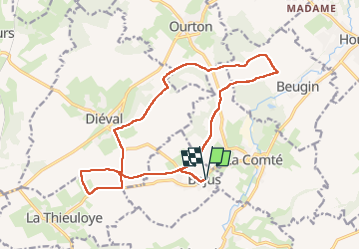
16.2 km
Max alt
166 m
Uphill gradient
212 m
Km-Effort
19 km
Min alt
88 m
Downhill gradient
212 m
Boucle
Yes
Creation date :
2022-04-23 12:17:29.0
Updated on :
2022-04-23 15:48:31.088
2h35
Difficulty : Difficult
FREE GPS app for hiking
 SityTrail
IGN / Geographical institutes
SityTrail Plus
The world is yours!
About
Trail Walking of 16.2 km to be discovered at Hauts-de-France, Pas-de-Calais, Bajus. This trail is proposed by 002029.720e260bc1c04b3a9c76aae5394fcda4.1547.
Description
Bajus
Positioning
Country:
France
Region :
Hauts-de-France
Department/Province :
Pas-de-Calais
Municipality :
Bajus
Location:
Unknown
Start:(Dec)
Start:(UTM)
463290 ; 5585661 (31U) N.
Comments