


calanques Cassis

inesmyt
User
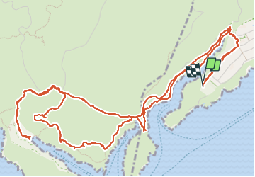

Length
10.2 km

Max alt
149 m

Uphill gradient
409 m
Km-Effort
15.6 km

Min alt
2 m

Downhill gradient
406 m
Boucle
Yes
Creation date :
2022-04-24 11:01:59.857
Updated on :
2022-04-24 15:07:41.899
4h04
Difficulty : Difficult

FREE GPS app for hiking
 SityTrail
IGN / Geographical institutes
SityTrail Plus
The world is yours!
About
Trail Walking of 10.2 km to be discovered at Provence-Alpes-Côte d'Azur, Bouches-du-Rhône, Cassis. This trail is proposed by inesmyt.
Positioning
Country:
France
Region :
Provence-Alpes-Côte d'Azur
Department/Province :
Bouches-du-Rhône
Municipality :
Cassis
Location:
Unknown
Start:(Dec)
Start:(UTM)
704623 ; 4786928 (31T) N.
Comments