


Balade

Atchoum26
User

Length
10.6 km

Max alt
250 m

Uphill gradient
102 m
Km-Effort
12.2 km

Min alt
110 m

Downhill gradient
177 m
Boucle
No
Creation date :
2022-04-24 12:43:23.086
Updated on :
2022-04-24 15:47:02.48
3h02
Difficulty : Very easy

FREE GPS app for hiking
 SityTrail
IGN / Geographical institutes
SityTrail Plus
The world is yours!
About
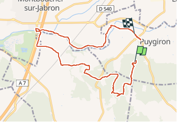
Trail Walking of 10.6 km to be discovered at Auvergne-Rhône-Alpes, Drôme, Puygiron. This trail is proposed by Atchoum26.
Description
Balade autour de Puygiron, Espeluche, Montboucher sur Jabron
Positioning
Country:
France
Region :
Auvergne-Rhône-Alpes
Department/Province :
Drôme
Municipality :
Puygiron
Location:
Unknown
Start:(Dec)
Start:(UTM)
646278 ; 4933264 (31T) N.
Comments