


Vals Thieure 25/04/22

Linerou
User
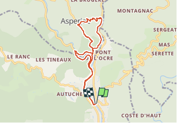

Length
8.4 km

Max alt
558 m

Uphill gradient
375 m
Km-Effort
13.5 km

Min alt
255 m

Downhill gradient
376 m
Boucle
Yes
Creation date :
2022-04-25 07:11:00.569
Updated on :
2022-04-25 10:24:08.312
2h33
Difficulty : Medium

FREE GPS app for hiking
 SityTrail
IGN / Geographical institutes
SityTrail Plus
The world is yours!
About
Trail Walking of 8.4 km to be discovered at Auvergne-Rhône-Alpes, Ardèche, Vals-les-Bains. This trail is proposed by Linerou.
Positioning
Country:
France
Region :
Auvergne-Rhône-Alpes
Department/Province :
Ardèche
Municipality :
Vals-les-Bains
Location:
Unknown
Start:(Dec)
Start:(UTM)
608267 ; 4946726 (31T) N.
Comments