


tetard

Nila81
User
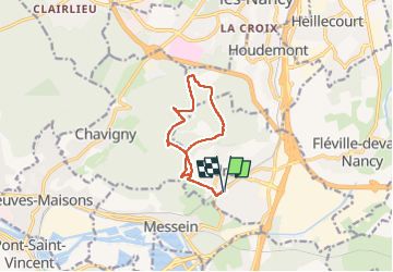

Length
9.8 km

Max alt
420 m

Uphill gradient
194 m
Km-Effort
12.4 km

Min alt
286 m

Downhill gradient
195 m
Boucle
Yes
Creation date :
2022-04-26 12:04:19.318
Updated on :
2022-04-26 14:37:20.486
2h31
Difficulty : Difficult

FREE GPS app for hiking
 SityTrail
IGN / Geographical institutes
SityTrail Plus
The world is yours!
About
Trail Walking of 9.8 km to be discovered at Grand Est, Meurthe-et-Moselle, Ludres. This trail is proposed by Nila81.
Positioning
Country:
France
Region :
Grand Est
Department/Province :
Meurthe-et-Moselle
Municipality :
Ludres
Location:
Unknown
Start:(Dec)
Start:(UTM)
290872 ; 5388777 (32U) N.
Comments