


Rando JMM 12 km l'Yerres-Reveillon

jeanmarcMasson
User GUIDE
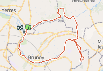

Length
11.8 km

Max alt
93 m

Uphill gradient
156 m
Km-Effort
13.9 km

Min alt
36 m

Downhill gradient
156 m
Boucle
Yes
Creation date :
2022-04-27 07:16:00.158
Updated on :
2022-04-27 10:19:41.853
2h44
Difficulty : Difficult

FREE GPS app for hiking
 SityTrail
IGN / Geographical institutes
SityTrail Plus
The world is yours!
About
Trail Walking of 11.8 km to be discovered at Ile-de-France, Essonne, Yerres. This trail is proposed by jeanmarcMasson.
Positioning
Country:
France
Region :
Ile-de-France
Department/Province :
Essonne
Municipality :
Yerres
Location:
Unknown
Start:(Dec)
Start:(UTM)
463020 ; 5395053 (31U) N.
Comments