


Theminette

Gegetop
User
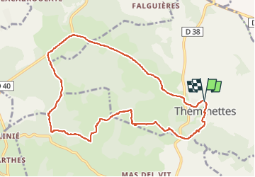

Length
10.7 km

Max alt
364 m

Uphill gradient
128 m
Km-Effort
12.4 km

Min alt
328 m

Downhill gradient
131 m
Boucle
Yes
Creation date :
2022-04-28 09:30:46.645
Updated on :
2022-04-29 14:04:43.66
2h36
Difficulty : Easy

FREE GPS app for hiking
 SityTrail
IGN / Geographical institutes
SityTrail Plus
The world is yours!
About
Trail Walking of 10.7 km to be discovered at Occitania, Lot, Théminettes. This trail is proposed by Gegetop.
Description
Balade typique du Causse avec ses paysages de pierres blanches et de murets centenaires.
Photos


Positioning
Country:
France
Region :
Occitania
Department/Province :
Lot
Municipality :
Théminettes
Location:
Unknown
Start:(Dec)
Start:(UTM)
409231 ; 4951906 (31T) N.
Comments