


St-Paul-G2-Boucles-des-Pins

Valmeinier
User
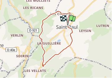

Length
7 km

Max alt
507 m

Uphill gradient
177 m
Km-Effort
9.4 km

Min alt
368 m

Downhill gradient
178 m
Boucle
Yes
Creation date :
2022-04-29 03:36:25.962
Updated on :
2022-04-29 03:36:25.962
2h07
Difficulty : Medium

FREE GPS app for hiking
 SityTrail
IGN / Geographical institutes
SityTrail Plus
The world is yours!
About
Trail Walking of 7 km to be discovered at Auvergne-Rhône-Alpes, Savoy, Saint-Paul. This trail is proposed by Valmeinier.
Positioning
Country:
France
Region :
Auvergne-Rhône-Alpes
Department/Province :
Savoy
Municipality :
Saint-Paul
Location:
Unknown
Start:(Dec)
Start:(UTM)
716919 ; 5061996 (31T) N.
Comments