


Tilleroyes

TRIMAILLE
User
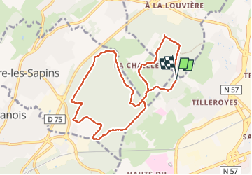

Length
9.4 km

Max alt
340 m

Uphill gradient
167 m
Km-Effort
11.6 km

Min alt
271 m

Downhill gradient
165 m
Boucle
Yes
Creation date :
2022-04-29 07:05:31.571
Updated on :
2022-04-29 09:37:00.836
2h04
Difficulty : Medium

FREE GPS app for hiking
 SityTrail
IGN / Geographical institutes
SityTrail Plus
The world is yours!
About
Trail Walking of 9.4 km to be discovered at Bourgogne-Franche-Comté, Doubs, Besançon. This trail is proposed by TRIMAILLE.
Positioning
Country:
France
Region :
Bourgogne-Franche-Comté
Department/Province :
Doubs
Municipality :
Besançon
Location:
Unknown
Start:(Dec)
Start:(UTM)
724450 ; 5236095 (31T) N.
Comments