Trail Walking Belle-Isle-en-Terre - 22 BELLE ÎLE EN TERRE petit circuit  - Photo

22 BELLE ÎLE EN TERRE petit circuit

© OpenStreetMap contributors
Length
Length
6.2 km
Max alt
Max alt
160 m
Uphill gradient
Uphill gradient
111 m
Km-Effort
Km-Effort  
7.6 km
Min alt
Min alt
90 m
Downhill gradient
Downhill gradient
111 m
Boucle
Boucle
Yes
Creation date :
2022-04-29 12:36:04.86
Updated on :
2022-04-29 14:34:02.068

(0 Reviews)

Walking
Walking
1h57
Difficulty : Very easy

Scan this QR Code to open this trail in the SityTrail application

FREE GPS app for hiking

Logo SityTrail SityTrail

IGN / Geographical institutes

Download SityTrail from the App Store Download SityTrail from Google Play

Logo SityTrail SityTrail World

The world is yours!

Download SityTrail from the App Store Download SityTrail from Google Play Download SityTrail on Huawei AppGallery

About

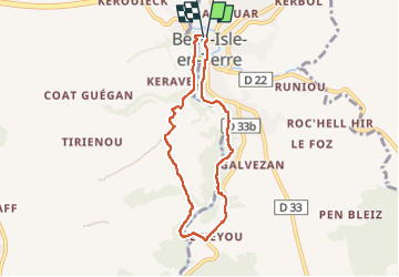
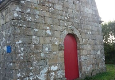
Trail Walking of 6.2 km to be discovered at Brittany, Côtes-d'Armor, Belle-Isle-en-Terre. This trail is proposed by Cosmos .

Description

En amont de LE GUIC

Elevation profile

Positioning

Country:
France
Region :
Brittany
Department/Province :
Côtes-d'Armor
Municipality :
Belle-Isle-en-Terre
Location:
Unknown
Start:(UTM)
470770 ; 5376983 (30U) N.

Trails nearby

Trail On foot Belle-Isle-en-Terre - Belle Isle en Terre - Le Dresnay - Photo
On foot
chessyca

On foot

Difficult
Belle-Isle-en-Terre, Brittany, Côtes-d'Armor, France
24 km | 32 km-effort
7h 10min
No
Trail Mountain bike Loc-Envel - Château de Coat an Noz - Loc Envel  - Photo
Mountain bike
tracegps

Mountain bike

Easy
Loc-Envel, Brittany, Côtes-d'Armor, France
6.7 km | 8.2 km-effort
45min
Yes
Trail Walking Plounévez-Moëdec - Vallée Kernansquillec - Photo
Walking
runarlejou

Walking

Medium
Plounévez-Moëdec, Brittany, Côtes-d'Armor, France
8.3 km | 10.8 km-effort
2h 33min
Yes
Trail Walking Plounévez-Moëdec - Boucle de Kernansquillec  - Photo
Walking
runarlejou

Walking

Medium
(1)
Plounévez-Moëdec, Brittany, Côtes-d'Armor, France
9.6 km | 12.4 km-effort
2h 54min
Yes
Trail Walking Louargat - au fil de l eau - Photo
Walking
symba

Walking

Very easy
Louargat, Brittany, Côtes-d'Armor, France
9.3 km | 10.7 km-effort
2h 22min
Yes
Trail On foot Loguivy-Plougras - 2022-04-02_21h02m51_SityTrail - 2870303 - botsorhelx22072021 - Photo
On foot
chessyca

On foot

Difficult
Loguivy-Plougras, Brittany, Côtes-d'Armor, France
26 km | 32 km-effort
7h 20min
No
Trail On foot Belle-Isle-en-Terre - 2022-04-02_21h02m08_SityTrail - 2869320 - le-dresnayx21072021 - Photo
On foot
chessyca

On foot

Medium
Belle-Isle-en-Terre, Brittany, Côtes-d'Armor, France
24 km | 31 km-effort
7h 0min
No
Trail Walking Loc-Envel - Loc Enveloppe - Photo
Walking
0658294C

Walking

Difficult
Loc-Envel, Brittany, Côtes-d'Armor, France
10.3 km | 13.2 km-effort
3h 5min
Yes
Trail Walking Loguivy-Plougras - Le Dresnay. Botsorhel  - Photo
Walking
aucamus

Walking

Very difficult
Loguivy-Plougras, Brittany, Côtes-d'Armor, France
27 km | 33 km-effort
9h 39min
No


Close
My subscriptions