


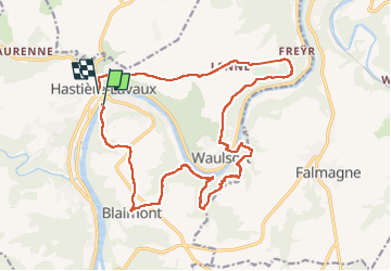
Hastier
© OpenStreetMap contributors


4h33
Difficulty : Very difficult


Length
18.8 km
Max alt
249 m
Uphill gradient
538 m
Km-Effort
26 km
Min alt
94 m
Downhill gradient
535 m
Boucle
No
Creation date :
2022-05-01 09:16:45.0
Updated on :
2022-05-01 14:43:36.927
4h33
Difficulty : Very difficult
FREE GPS app for hiking
 SityTrail
IGN / Geographical institutes
SityTrail Plus
The world is yours!
About
Trail Walking of 18.8 km to be discovered at Wallonia, Namur, Hastière. This trail is proposed by 001433.7bed7ed0214a4463aa3b337c51a300eb.1151.
Positioning
Country:
Belgium
Region :
Wallonia
Department/Province :
Namur
Municipality :
Hastière
Location:
Unknown
Start:(Dec)
Start:(UTM)
630274 ; 5564031 (31U) N.
Comments