


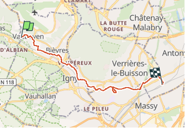
En descendant la Bièvre

canal
User

Length
11.5 km

Max alt
142 m

Uphill gradient
118 m
Km-Effort
13.1 km

Min alt
52 m

Downhill gradient
133 m
Boucle
No
Creation date :
2022-05-02 08:44:32.738
Updated on :
2022-05-02 13:22:14.579
4h37
Difficulty : Difficult

FREE GPS app for hiking
 SityTrail
IGN / Geographical institutes
SityTrail Plus
The world is yours!
About
Trail Walking of 11.5 km to be discovered at Ile-de-France, Essonne, Bièvres. This trail is proposed by canal.
Description
Les parties à l'air libre de la Bièvre
Positioning
Country:
France
Region :
Ile-de-France
Department/Province :
Essonne
Municipality :
Bièvres
Location:
Unknown
Start:(Dec)
Start:(UTM)
440708 ; 5401133 (31U) N.
Comments