


exp_02-05-22_traces

sandra_leb
User
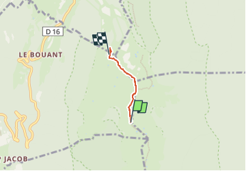

Length
2 km

Max alt
1610 m

Uphill gradient
40 m
Km-Effort
2.8 km

Min alt
1498 m

Downhill gradient
133 m
Boucle
No
Creation date :
2022-05-02 14:29:37.0
Updated on :
2022-05-02 14:29:38.321

FREE GPS app for hiking
 SityTrail
IGN / Geographical institutes
SityTrail Plus
The world is yours!
About
Trail of 2 km to be discovered at Auvergne-Rhône-Alpes, Ain, Confort. This trail is proposed by sandra_leb.
Positioning
Country:
France
Region :
Auvergne-Rhône-Alpes
Department/Province :
Ain
Municipality :
Confort
Location:
Unknown
Start:(Dec)
Start:(UTM)
721142 ; 5114748 (31T) N.
Comments