


l'AIGRE / COLS DES SACS/PAS d'ADAM

Michel DUBOIS
User
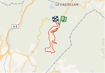

Length
12.8 km

Max alt
444 m

Uphill gradient
407 m
Km-Effort
18.3 km

Min alt
135 m

Downhill gradient
402 m
Boucle
Yes
Creation date :
2022-05-03 07:11:12.586
Updated on :
2022-05-03 07:13:32.304
4h08
Difficulty : Medium

FREE GPS app for hiking
 SityTrail
IGN / Geographical institutes
SityTrail Plus
The world is yours!
About
Trail Walking of 12.8 km to be discovered at Provence-Alpes-Côte d'Azur, Var, Fréjus. This trail is proposed by Michel DUBOIS.
Positioning
Country:
France
Region :
Provence-Alpes-Côte d'Azur
Department/Province :
Var
Municipality :
Fréjus
Location:
Unknown
Start:(Dec)
Start:(UTM)
322291 ; 4818291 (32T) N.
Comments
superbe rando physique dans le 2eme tiers