


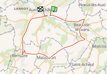
auxi maizicoirt

Martelpierre
User

Length
16 km

Max alt
124 m

Uphill gradient
162 m
Km-Effort
18.1 km

Min alt
31 m

Downhill gradient
164 m
Boucle
No
Creation date :
2022-05-03 09:03:17.024
Updated on :
2022-05-03 10:22:16.687
1h15
Difficulty : Easy

FREE GPS app for hiking
 SityTrail
IGN / Geographical institutes
SityTrail Plus
The world is yours!
About
Trail Mountain bike of 16 km to be discovered at Hauts-de-France, Pas-de-Calais, Auxi-le-Château. This trail is proposed by Martelpierre.
Description
tout par trouée Beauvoir maizicoirt bernatre et retour par trouée du Ponthieu
Positioning
Country:
France
Region :
Hauts-de-France
Department/Province :
Pas-de-Calais
Municipality :
Auxi-le-Château
Location:
Unknown
Start:(Dec)
Start:(UTM)
437641 ; 5564223 (31U) N.
Comments