


ITI0023

jeanic63
User

Length
14.2 km

Max alt
916 m

Uphill gradient
299 m
Km-Effort
18.2 km

Min alt
759 m

Downhill gradient
301 m
Boucle
Yes
Creation date :
2022-05-04 16:11:53.868
Updated on :
2022-05-04 16:37:52.771
4h08
Difficulty : Medium

FREE GPS app for hiking
 SityTrail
IGN / Geographical institutes
SityTrail Plus
The world is yours!
About
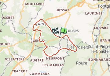
Trail On foot of 14.2 km to be discovered at Auvergne-Rhône-Alpes, Puy-de-Dôme, Bromont-Lamothe. This trail is proposed by jeanic63.
Description
départ sortie Bromont Lamothe D72 et 572 aprés Peyrouse
Positioning
Country:
France
Region :
Auvergne-Rhône-Alpes
Department/Province :
Puy-de-Dôme
Municipality :
Bromont-Lamothe
Location:
Unknown
Start:(Dec)
Start:(UTM)
484201 ; 5072713 (31T) N.
Comments