


monistrol sauges

raab
User
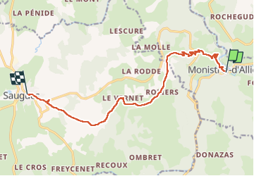

Length
13 km

Max alt
1101 m

Uphill gradient
572 m
Km-Effort
19.5 km

Min alt
597 m

Downhill gradient
238 m
Boucle
No
Creation date :
2022-05-05 07:46:04.865
Updated on :
2022-05-05 12:24:09.825
4h36
Difficulty : Very difficult

FREE GPS app for hiking
 SityTrail
IGN / Geographical institutes
SityTrail Plus
The world is yours!
About
Trail Walking of 13 km to be discovered at Auvergne-Rhône-Alpes, Haute-Loire, Monistrol-d'Allier. This trail is proposed by raab.
Positioning
Country:
France
Region :
Auvergne-Rhône-Alpes
Department/Province :
Haute-Loire
Municipality :
Monistrol-d'Allier
Location:
Unknown
Start:(Dec)
Start:(UTM)
550816 ; 4979513 (31T) N.
Comments