


bat sur Aube

pierrol
User
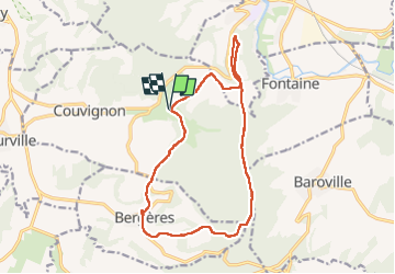

Length
15.1 km

Max alt
368 m

Uphill gradient
339 m
Km-Effort
19.6 km

Min alt
237 m

Downhill gradient
338 m
Boucle
Yes
Creation date :
2022-05-07 09:10:18.695
Updated on :
2022-05-08 06:43:51.322
5h40
Difficulty : Easy

FREE GPS app for hiking
 SityTrail
IGN / Geographical institutes
SityTrail Plus
The world is yours!
About
Trail Walking of 15.1 km to be discovered at Grand Est, Aube, Couvignon. This trail is proposed by pierrol.
Positioning
Country:
France
Region :
Grand Est
Department/Province :
Aube
Municipality :
Couvignon
Location:
Unknown
Start:(Dec)
Start:(UTM)
624505 ; 5340741 (31U) N.
Comments