


2022 05 Louteville

michel1025
User
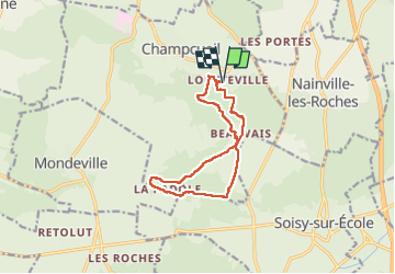

Length
11.2 km

Max alt
147 m

Uphill gradient
192 m
Km-Effort
13.7 km

Min alt
82 m

Downhill gradient
193 m
Boucle
Yes
Creation date :
2022-05-08 13:36:31.0
Updated on :
2022-05-08 20:23:46.154
2h51
Difficulty : Difficult

FREE GPS app for hiking
 SityTrail
IGN / Geographical institutes
SityTrail Plus
The world is yours!
About
Trail Walking of 11.2 km to be discovered at Ile-de-France, Essonne, Champcueil. This trail is proposed by michel1025.
Positioning
Country:
France
Region :
Ile-de-France
Department/Province :
Essonne
Municipality :
Champcueil
Location:
Unknown
Start:(Dec)
Start:(UTM)
460365 ; 5372887 (31U) N.
Comments