


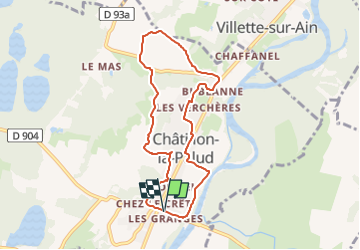
Chatillon La Palud-Circuit de Gévrieux

ThierryJ01
User

Length
7.5 km

Max alt
316 m

Uphill gradient
154 m
Km-Effort
9.6 km

Min alt
221 m

Downhill gradient
152 m
Boucle
Yes
Creation date :
2022-05-08 21:28:09.453
Updated on :
2022-05-08 21:31:10.316
2h10
Difficulty : Medium

FREE GPS app for hiking
 SityTrail
IGN / Geographical institutes
SityTrail Plus
The world is yours!
About
Trail Walking of 7.5 km to be discovered at Auvergne-Rhône-Alpes, Ain, Châtillon-la-Palud. This trail is proposed by ThierryJ01.
Points of interest


Positioning
Country:
France
Region :
Auvergne-Rhône-Alpes
Department/Province :
Ain
Municipality :
Châtillon-la-Palud
Location:
Unknown
Start:(Dec)
Start:(UTM)
674438 ; 5092709 (31T) N.
Comments