


sentier botanique

papou73
User
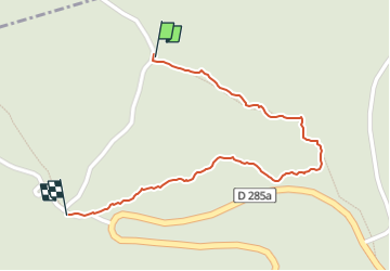

Length
840 m

Max alt
664 m

Uphill gradient
30 m
Km-Effort
1.1 km

Min alt
631 m

Downhill gradient
1 m
Boucle
No
Creation date :
2022-05-09 14:08:06.464
Updated on :
2022-05-09 14:37:28.096
19m
Difficulty : Easy

FREE GPS app for hiking
 SityTrail
IGN / Geographical institutes
SityTrail Plus
The world is yours!
About
Trail Walking of 840 m to be discovered at Auvergne-Rhône-Alpes, Isère, Chapareillan. This trail is proposed by papou73.
Positioning
Country:
France
Region :
Auvergne-Rhône-Alpes
Department/Province :
Isère
Municipality :
Chapareillan
Location:
Unknown
Start:(Dec)
Start:(UTM)
730499 ; 5040819 (31T) N.
Comments