


rando

Eve - Line
User
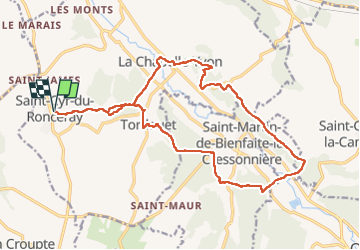

Length
18.8 km

Max alt
175 m

Uphill gradient
449 m
Km-Effort
25 km

Min alt
78 m

Downhill gradient
448 m
Boucle
Yes
Creation date :
2022-05-10 06:04:26.792
Updated on :
2022-05-10 10:26:29.987
4h21
Difficulty : Very difficult

FREE GPS app for hiking
 SityTrail
IGN / Geographical institutes
SityTrail Plus
The world is yours!
About
Trail Walking of 18.8 km to be discovered at Normandy, Calvados, Valorbiquet. This trail is proposed by Eve - Line.
Positioning
Country:
France
Region :
Normandy
Department/Province :
Calvados
Municipality :
Valorbiquet
Location:
Saint-Cyr-du-Ronceray
Start:(Dec)
Start:(UTM)
302650 ; 5436893 (31U) N.
Comments