


Villevocance

JacouBrijou
User
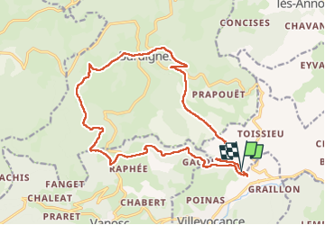

Length
20 km

Max alt
1054 m

Uphill gradient
788 m
Km-Effort
31 km

Min alt
422 m

Downhill gradient
787 m
Boucle
Yes
Creation date :
2022-05-10 06:17:13.906
Updated on :
2022-05-10 13:48:57.614
7h29
Difficulty : Medium

FREE GPS app for hiking
 SityTrail
IGN / Geographical institutes
SityTrail Plus
The world is yours!
About
Trail Walking of 20 km to be discovered at Auvergne-Rhône-Alpes, Ardèche, Villevocance. This trail is proposed by JacouBrijou.
Description
20 km - Très belle randonnée !
Positioning
Country:
France
Region :
Auvergne-Rhône-Alpes
Department/Province :
Ardèche
Municipality :
Villevocance
Location:
Unknown
Start:(Dec)
Start:(UTM)
625619 ; 5010706 (31T) N.
Comments