


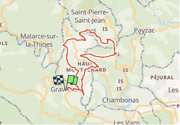
Graviers Les Vans

Monjean
User

Length
18.2 km

Max alt
425 m

Uphill gradient
584 m
Km-Effort
26 km

Min alt
160 m

Downhill gradient
584 m
Boucle
Yes
Creation date :
2022-05-10 07:28:16.089
Updated on :
2022-05-10 14:57:46.005
7h26
Difficulty : Very difficult

FREE GPS app for hiking
 SityTrail
IGN / Geographical institutes
SityTrail Plus
The world is yours!
About
Trail Walking of 18.2 km to be discovered at Auvergne-Rhône-Alpes, Ardèche, Gravières. This trail is proposed by Monjean.
Positioning
Country:
France
Region :
Auvergne-Rhône-Alpes
Department/Province :
Ardèche
Municipality :
Gravières
Location:
Unknown
Start:(Dec)
Start:(UTM)
586888 ; 4919229 (31T) N.
Comments