


St Melany

Monjean
User
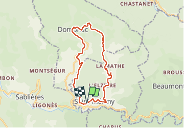

Length
15.4 km

Max alt
757 m

Uphill gradient
631 m
Km-Effort
24 km

Min alt
376 m

Downhill gradient
631 m
Boucle
Yes
Creation date :
2022-05-11 07:20:40.472
Updated on :
2022-05-11 13:34:25.12
6h12
Difficulty : Very difficult

FREE GPS app for hiking
 SityTrail
IGN / Geographical institutes
SityTrail Plus
The world is yours!
About
Trail Walking of 15.4 km to be discovered at Auvergne-Rhône-Alpes, Ardèche, Saint-Mélany. This trail is proposed by Monjean.
Description
sentier des Lauze
Positioning
Country:
France
Region :
Auvergne-Rhône-Alpes
Department/Province :
Ardèche
Municipality :
Saint-Mélany
Location:
Unknown
Start:(Dec)
Start:(UTM)
588438 ; 4931205 (31T) N.
Comments