


Vallée de la Houille

ameurant
User

Length
24 km

Max alt
414 m

Uphill gradient
403 m
Km-Effort
29 km

Min alt
227 m

Downhill gradient
401 m
Boucle
Yes
Creation date :
2014-12-10 00:00:00.0
Updated on :
2014-12-10 00:00:00.0
5h36
Difficulty : Unknown

FREE GPS app for hiking
 SityTrail
IGN / Geographical institutes
SityTrail Plus
The world is yours!
About
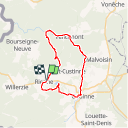
Trail Walking of 24 km to be discovered at Wallonia, Namur, Gedinne. This trail is proposed by ameurant.
Description
Rienne, Etange de Boiron, Gedinne, Zone des Castors, Vencimont, Rienne
Positioning
Country:
Belgium
Region :
Wallonia
Department/Province :
Namur
Municipality :
Gedinne
Location:
Rienne
Start:(Dec)
Start:(UTM)
635368 ; 5539539 (31U) N.
Comments