


Les tonils

raygautier
User
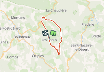

Length
21 km

Max alt
1515 m

Uphill gradient
1111 m
Km-Effort
36 km

Min alt
552 m

Downhill gradient
1113 m
Boucle
Yes
Creation date :
2022-05-12 06:41:11.0
Updated on :
2022-05-12 19:25:23.442
5h11
Difficulty : Very difficult

FREE GPS app for hiking
 SityTrail
IGN / Geographical institutes
SityTrail Plus
The world is yours!
About
Trail Walking of 21 km to be discovered at Auvergne-Rhône-Alpes, Drôme, Les Tonils. This trail is proposed by raygautier.
Positioning
Country:
France
Region :
Auvergne-Rhône-Alpes
Department/Province :
Drôme
Municipality :
Les Tonils
Location:
Unknown
Start:(Dec)
Start:(UTM)
674616 ; 4938862 (31T) N.
Comments