


viterne

topnature !
User
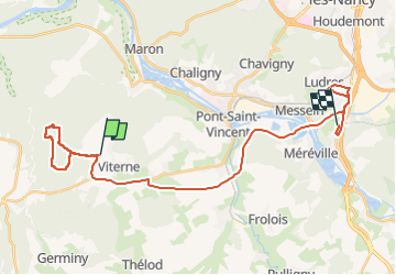

Length
30 km

Max alt
363 m

Uphill gradient
351 m
Km-Effort
35 km

Min alt
212 m

Downhill gradient
419 m
Boucle
No
Creation date :
2022-05-13 11:48:32.0
Updated on :
2022-05-13 15:52:32.535
4h00
Difficulty : Easy

FREE GPS app for hiking
 SityTrail
IGN / Geographical institutes
SityTrail Plus
The world is yours!
About
Trail Walking of 30 km to be discovered at Grand Est, Meurthe-et-Moselle, Viterne. This trail is proposed by topnature !.
Description
La Croix des aviateurs
Balade forestière
Positioning
Country:
France
Region :
Grand Est
Department/Province :
Meurthe-et-Moselle
Municipality :
Viterne
Location:
Unknown
Start:(Dec)
Start:(UTM)
280392 ; 5386356 (32U) N.
Comments