


anduzesthippolyte

jpfrobert
User
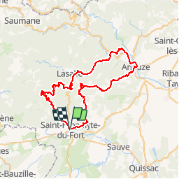

Length
66 km

Max alt
630 m

Uphill gradient
1362 m
Km-Effort
85 km

Min alt
128 m

Downhill gradient
1363 m
Boucle
Yes
Creation date :
2014-12-10 00:00:00.0
Updated on :
2014-12-10 00:00:00.0
4h46
Difficulty : Medium

FREE GPS app for hiking
 SityTrail
IGN / Geographical institutes
SityTrail Plus
The world is yours!
About
Trail Cycle of 66 km to be discovered at Occitania, Gard, Saint-Hippolyte-du-Fort. This trail is proposed by jpfrobert.


Positioning
Country:
France
Region :
Occitania
Department/Province :
Gard
Municipality :
Saint-Hippolyte-du-Fort
Location:
Unknown
Start:(Dec)
Start:(UTM)
568596 ; 4868356 (31T) N.
Comments