


Luzarche bis

mouchette94
User
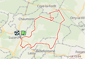

Length
19.7 km

Max alt
137 m

Uphill gradient
310 m
Km-Effort
24 km

Min alt
44 m

Downhill gradient
309 m
Boucle
Yes
Creation date :
2022-05-17 07:24:07.0
Updated on :
2022-05-17 13:22:14.678
4h43
Difficulty : Medium

FREE GPS app for hiking
 SityTrail
IGN / Geographical institutes
SityTrail Plus
The world is yours!
About
Trail Walking of 19.7 km to be discovered at Ile-de-France, Val-d'Oise, Luzarches. This trail is proposed by mouchette94.
Positioning
Country:
France
Region :
Ile-de-France
Department/Province :
Val-d'Oise
Municipality :
Luzarches
Location:
Unknown
Start:(Dec)
Start:(UTM)
458318 ; 5440012 (31U) N.
Comments