


roche des Arnaud reco1

guyzinz
User
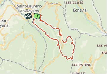

Length
17.9 km

Max alt
1390 m

Uphill gradient
1194 m
Km-Effort
34 km

Min alt
372 m

Downhill gradient
1208 m
Boucle
Yes
Creation date :
2022-05-17 06:03:14.181
Updated on :
2022-05-17 13:30:49.096
6h55
Difficulty : Very difficult

FREE GPS app for hiking
 SityTrail
IGN / Geographical institutes
SityTrail Plus
The world is yours!
About
Trail Walking of 17.9 km to be discovered at Auvergne-Rhône-Alpes, Drôme, Saint-Laurent-en-Royans. This trail is proposed by guyzinz.
Positioning
Country:
France
Region :
Auvergne-Rhône-Alpes
Department/Province :
Drôme
Municipality :
Saint-Laurent-en-Royans
Location:
Unknown
Start:(Dec)
Start:(UTM)
683611 ; 4987380 (31T) N.
Comments